


Market Overview and Growth Outlook
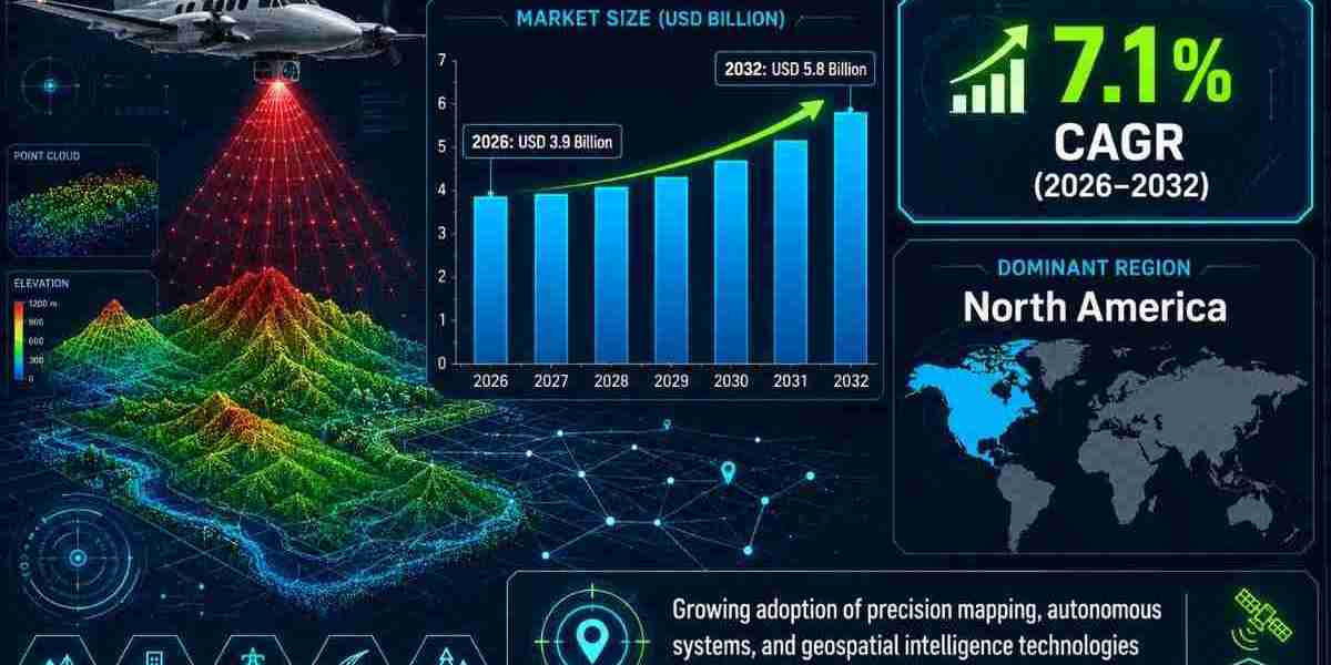
Annual demand in the Airborne LiDAR Market stood at USD 3.6 billion in 2025 and is estimated at USD 3.9 billion in 2026. The market is projected to reach USD 5.8 billion by 2032, representing approximately 1.6 times the expected 2026 demand and a cumulative opportunity of USD 37.6 billion.
The Airborne LiDAR Market is expected to grow at a CAGR of 7.1% during 2026-2032. This trajectory is linked to increasing requirements for precise elevation models, large-scale aerial surveying, three-dimensional city mapping, digital terrain intelligence, infrastructure planning, and environmental-risk assessment.
Airborne LiDAR uses pulsed laser technology to calculate distances and generate detailed three-dimensional information about terrestrial or underwater features. Its ability to capture elevation data under dense vegetation and across complex terrain provides a performance advantage for applications requiring reliable digital terrain models and digital surface models.
The expanding Airborne LiDAR Market size reflects its growing role in civil engineering and government-led mapping programs. Demand is increasingly connected to smart infrastructure, digital twins, wide-area surveys, climate resilience, defense terrain modelling, utility planning, and high-resolution environmental analysis.
Request a free sample report:
https://www.stratviewresearch.com/Request-Sample/Airborne-LiDAR-Market#form
Market Segmentation Analysis
The Type segmentation comprises Topographic, Bathymetric, and Topo-bathymetric. Topographic dominates the forecast period because it is extensively used for city and country mapping, urban planning, transportation infrastructure, utility mapping, and forestry analysis. Infrared wavelength technology enables accurate terrestrial elevation and terrain measurement for large-scale geographic projects.
Bathymetric technology uses green wavelength lasers to penetrate water surfaces and support coastal engineering, nautical charting, habitat mapping, and coastal zone management. Topo-bathymetric combines land and underwater surveying capabilities, extending the technology’s relevance where integrated terrain and shallow-water information is required.
The Solution Type System segmentation comprises System and Services. Services dominates and is also expected to record the fastest growth. The structural factor supporting this position is the increasing outsourcing of aerial surveying and geospatial data processing to specialized providers with mapping, point-cloud management, and project-delivery capabilities.
The Service Application Type segmentation comprises Corridor Mapping, Wide-Area Mapping, Natural Resources, and Others. Wide-Area Mapping remains dominant because national and regional projects require scalable coverage, high data accuracy, and extensive geographic datasets for urban mapping, terrain analysis, infrastructure development, and flood-risk assessment.
The End-User Type segmentation comprises Aerospace & Defense, Civil Engineering, Forestry & Agriculture, Transportation, Mining, and Others. Civil Engineering remains the largest end-user segment because infrastructure development and country-wide planning depend on accurate digital terrain models and digital surface models.
Regional Market Insights
North America remains the largest regional market, supported by strong aerial-surveying adoption across public and private organizations. Large mapping programs conducted by government, engineering, utility, and environmental bodies create sustained demand for high-resolution elevation data, terrain models, and geospatial intelligence.
Asia-Pacific is expected to experience the fastest growth. Infrastructure expansion, smart-city initiatives, and rising investment in geospatial intelligence systems are increasing the use of airborne LiDAR for urban modelling, utility planning, terrain analysis, and infrastructure modernization.
Emerging Trends Shaping the Airborne LiDAR Market
The market is shifting toward automated geospatial processing. Artificial intelligence supports point-cloud classification, feature extraction, and real-time spatial modelling. Integration with digital twin platforms enables large datasets to be converted into structured three-dimensional information for infrastructure and environmental planning.
Another trend is the movement toward wide-area and national mapping. Large geographic surveys require scalable data acquisition and consistent terrain accuracy. This supports the dominance of Wide-Area Mapping and strengthens demand for specialized Services capable of processing and delivering extensive geospatial datasets.
Climate intelligence is also influencing the industry outlook. Airborne LiDAR datasets support flood modelling, wildfire-risk assessment, slope analysis, coastal inundation studies, and environmental-risk monitoring. These uses connect accurate terrain information with planning for disaster preparedness and climate resilience.
Key Growth Drivers of the Market
- Accurate terrain modelling: Reliable elevation data improves digital terrain and surface models used in infrastructure planning, engineering assessments, forestry, and environmental analysis.
- Wide-area surveying demand: National and regional mapping projects require scalable aerial data collection, supporting service providers and high-capacity geospatial processing operations.
- Outsourcing of mapping services: Organizations increasingly engage specialized providers for aerial surveys and point-cloud processing, strengthening the dominant and fastest-growing Services segment.
- Infrastructure modernization: Urban planning, transport networks, utility mapping, and smart-city development require current three-dimensional spatial data for effective design and management.
- Environmental-risk assessment: Demand for flood, wildfire, landslide, and coastal-risk mapping expands the use of high-resolution elevation datasets in resilience and disaster planning.
Competitive Landscape
Top Companies in the Market
Flir Systems Inc.
Hexagon AB (Leica Geosystems)
Pheonix Lidar Systems
RIEGL
Teledyne Technologies, Inc.
Velodyne LiDAR
YellowScan
AAM Pty. Ltd.
Bluesky
COWI A/S
DIELMO3D.
Diobotics
EUROSENSE GmbH
Fugro N.V.
Merrick & Company
Quantum Spatial, Inc.
Woolpert Inc
The competitive landscape includes system manufacturers and airborne LiDAR service providers. The market is fragmented, with fewer than 100 global and regional participants. Established companies compete through product portfolios, distribution networks, technical experience, sensor capabilities, and end-to-end mapping and data-processing services.
Conclusion and Strategic Outlook
The Airborne LiDAR Market is forecast to reach USD 5.8 billion by 2032 from USD 3.6 billion in 2025. A 7.1% CAGR during 2026-2032 reflects expanding requirements for elevation intelligence, infrastructure mapping, environmental analysis, and automated geospatial processing.
The market outlook remains closely linked to Topographic technology, Services, Wide-Area Mapping, and Civil Engineering. North America provides the largest current regional opportunity, while Asia-Pacific represents the fastest-growing regional market. Future industry development will be shaped by data accuracy, processing efficiency, operational costs, and regulatory access.
FAQs – Airborne LiDAR Market
1. How large will the Airborne LiDAR Market become?
The Airborne LiDAR Market is projected to reach USD 5.8 billion by 2032. It was valued at USD 3.6 billion in 2025 and is expected to reach USD 3.9 billion in 2026.
2. How rapidly is the market expected to expand?
The Airborne LiDAR Market is expected to register a CAGR of 7.1% during 2026-2032. Its cumulative sales opportunity during the forecast period is projected at USD 37.6 billion.
3. Why is demand for airborne LiDAR increasing?
Demand is increasing because airborne LiDAR provides accurate elevation data across dense vegetation and complex terrain. Smart infrastructure, digital twins, wide-area mapping, and disaster-risk analysis further extend its applications.
4. What does the regional analysis indicate?
North America is projected to remain the largest market, supported by extensive aerial mapping activity. Asia-Pacific is expected to grow fastest because of infrastructure expansion, smart cities, and geospatial intelligence investments.
5. What could limit market expansion?
High operational and data-processing expenses may restrict adoption, particularly among smaller surveying companies. Airspace regulations, flight permissions, and aviation compliance requirements can also lengthen survey timelines.